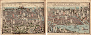
I immediately fallen in love with this map - it is not only in reasonable quality, but the actual, 3D like layout really makes it standing out from our collection.
Although street names are not visible owing to its overview nature it is really well reflecting the layout of Osaka, in Japan, showing the names of suburbs on a flag-like features. The locations of the bridges are also easy to be identified along with bays, shores and street layouts.
The whole map is making an impression of being a landscape drawing rather a map, yet it literally provides a very good navigational mean within the city's street furniture and topographic layout.
Last but not least, reasonable buildings with monumental/historical or governmental value are well shown - for instance at the bottom middle section it seems like that a royal palace like building is situated on the top of a small hill.

No comments:
Post a Comment